
Deer Creek Hills Preserve
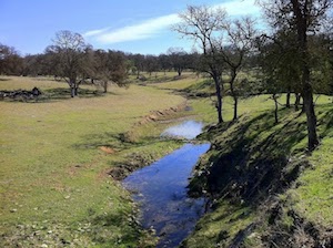
The preserve is a beautiful, varied area on the eastern edge of Sacramento County and the Sacramento Valley. Its rolling hills include blue oak woodlands and grasslands with a complex system of creeks and a variety of interesting rock formations.
The area had been used for private agriculture for more than 100 years and evidence of its habitation still exists. Gold was sought but never found, but long ditches dug by miners wind around hills in some areas.
In 1997, developers proposed building 3,000 luxury homes on 1,892 acres of Deer Creek Hills (similar to the Rancho Murieta development just to the south). Sacramento County supervisors rejected the proposal due to lack of urban services. The developers put an initiative on the ballot, but Sacramento County voters rejected it.
The Sacramento Valley Conservancy (SVC), in collaboration with the county and the state, launched a successful campaign to acquire the land as well as the adjoining acreage that now makes up the total preserve area. SVC now owns the preserve in partnership with the County of Sacramento, the California Department of Fish and Game and the California Department of Parks and Recreation. The Conservancy manages the site with input from local ranchers, adjacent landowners and the general public. Preserve uses include habitat preservation, cattle grazing, and public use.
Deer Creek Hills' 4,060 acres of rolling grasslands and oak woodland preserves the heritage of working ranches and provides endless opportunities for public recreation. The oaks and grasslands also provide habitat for approximately 170 species of birds, 105 mammal species, 58 amphibians and reptiles, and an estimated 5,000 kinds of insects.
SVC's mission is to preserve the beauty, character and diversity of the Sacramento Valley landscape. Formed in 1990, the first local land trust in Sacramento County, SVC is an accredited land trust and nonprofit organization with a record of excellence in preserving open space for agricultural, scenic, recreational and habitat purposes. SVC has permanently protected over 18,000 acres including regional trail systems, vernal pool preserves and oak woodlands in Sacramento, Amador and Yolo counties.
Directions:
From Sacramento: Take Highway 50 to the Bradshaw Exit, turn right (south) onto Bradshaw, turn left (east) onto Jackson Road (Highway 16), continue east, past the Dillard Road light and turn left on Latrobe Road. Follow this past Scott Road to a severe right turn onto Stone House Road. Do not make this turn, but rather travel straight onto a dirt road, the continuation of Latrobe Road. Park here if you wish to carpool with others. Travel approximately one mile to the Eagle Camp Corral. This part of Latrobe is very rocky and rutted. When crossing Crevis Creek, it is HIGHLY RECOMMENDED crossing the extreme left side of the road. This is the shallowest section of the creek.
From Folsom: Take Highway 50 to Prairie City Road Exit. Turn south onto Prairie City Road. Prairie City Road will dead-end into White Rock Road. Turn left (east) onto White Rock Road and travel about one mile. Turn right (south) onto Scott Road. Scott Road will dead-end into Latrobe Road. Turn left (east) onto Latrobe Road. Travel a short distance to a severe right turn onto Stone House Road. Do not make this turn, but rather travel straight onto a dirt road, the continuation of Latrobe Road. Park here if you wish to carpool with others. Travel approximately one mile to the Eagle Camp Corral. This part of Latrobe is very rocky and rutted. When crossing Crevis Creek, it is HIGHLY RECOMMENDED crossing the extreme left side of the road. This is the shallowest section of the creek.
Here is the Sacramento Valley Conservancy website.
This is a SVC brochure about Deer Creek Hills.
Here is the Sacramento County Regional Parks DCH page.
A Google map is here.
Back to Sites