Maps
The most important skill needed in orienteering is being able to read an orienteering map. Maps made for orienteering are very detailed, often showing individual boulders, lone trees and small indistinct paths. It is the ability to look at the symbols on these maps and relate them with the terrain around you that determines how well you will do in finding the flags at the various stations on your course.
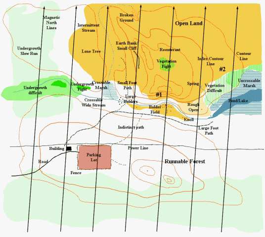
One of the most obvious markings on these maps are several parallel black lines going across the map. It is these lines along with your compass that you use to orient the map with your surroundings and magnetic north . Another feature on these maps are brown curved lines. These lines are contour lines and show the shape of the land on the map such as hills, valleys, cliffs or very steep areas and flat areas. When you see a lot of lines close together then you know the land is steep or even a cliff (see #1 on sample). When the lines are far apart the land is relatively flat or slopping very gently (see #2 on sample).
The next obvious markings on these maps are colors. These colors represent what kind of terrain is at that area. White is runnable forest and yellow-orange is open runnable land. Green areas shows areas where vegetation will slow you down (the darker green, the denser the vegetation). Areas with blue represent water and can also slow you down or stop you altogether. Black curved lines (solid or dashed) represent roads or paths and provide the easiest way to go across land if they go to where you need to go. The easiest courses will make use of these roads, paths, and trails, while the more difficult courses avoid easy use of paths to go from point to point. The rest of the symbols on the maps can represent almost anything that you may find out there: buildings, caves, pits, knolls, fences, cliffs, boulders, individual trees, etc.
Back to How To Orienteer